This past weekend we tried the same hiking recipe as the weekend before: a new hiking route on Saturday, this time around Old Town Fairfax, Virginia; followed by an old favorite on Sunday, Difficult Run, starting from Colvin Run Mill and heading downstream.
The starting point for Saturday’s hike was the Stacy C. Sherwood Center, a nice community center just north of Old Town Fairfax along Old Lee Highway. The route consisted of two legs: first, a 1.7 mile loop (traced in red on the map below) along sidewalks through Old Town, taking in a few of the historic buildings along the way; and second, a 3.5 mile out-and-back hike through Daniel’s Run Park. The loop through Old Town was surely not as detailed as one of the 90-minute guided tours offered by Historic Fairfax City, but on the other hand, there wasn’t a $5 per-person fee, either! Since our goal was to keep moving, rather than stopping at each site for a lengthy discussion, I handed out a little map with descriptions of the sites taken from the Historical Marker Database. (A pdf version is available here.) This also had the fringe benefit of helping me to keep my mouth shut. (What was that quote from Abraham Lincoln again? “It is better to remain silent and be thought a fool than to speak out and remove all doubt.”) 😀
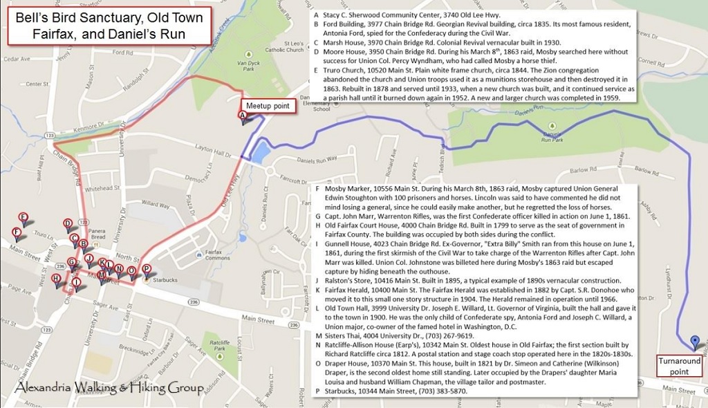 Striking out east along the Daniel’s Run Trail (traced in blue on the map above), we passed a pleasant little pond with a fountain and a blue heron keeping an eye on things before we disappeared into the deep woods. The cool quiet and tall trees are so peaceful that, except for the occasional signpost indicating a path leading to one of the surrounding streets, you would almost think you left the city behind!

")


Sunday’s hike was a lot more “countrified” — after leaving Colvin Run Mill and entering the Difficult Run Trail, it was 5.5 miles of shaded dirt and mud trails, moderate to easy difficulty level, and broken only by one road and four stream shady crossings. I hadn’t been there in two years, but nothing has changed, and the stream crossings are sturdy enough that Difficult Run has to be really high in order to prevent a crossing.


All told, the two hikes yielded 10.7 miles of smiles. I really like coming up with fresh routes to hike rather than the same old cookie-cutter hikes that everyone knows by name. That’s not to say the familiar ones are bad; it’s just like retelling a favorite story — you already know how it ends. The only rub is finding the time to reconnoiter them in advance, since the map and the real thing can be considerably different!


Lovely!
Your hikes sound and look delightful. So much history, too. I suppose it makes you think who has walked here before you.
Looks beautiful, John! Your pictures put me right there and I love the “wetness” everywhere: the air, the rocks, the ground, the fauna. It’s so different than the dry air out here in AZ.