The Guns of Autumn: Forts Foote and Washington

Last weekend was not only a long one (because of Veterans Day), but also about the last hurrah for autumn colors here in northern Virginia. To take advantage of the extra day our hiking group did three hikes over the weekend!

The first two, Burke Lake and Lake Accotink, were repeat hikes, but always nice to visit when the leaves are brilliant. Burke Lake, on Saturday, was a 4.7-mile hike, and certainly more appealing than when I last visited in March! Sunday’s visit to Lake Accotink was the first since last November, and the 5.2-mile hike yielded the same wonderful Autumn experience.

The most exciting event was reserved for Veterans Day itself, in a visit to Forts Foote and Washington, two scenic landmarks that once stood watch over the sea approaches to our Nation’s capital.

I wasn’t too sure how this two-location event would work out, especially since we started off carpooling from a third location, the King Street Metro Center in Alexandria. The answer was, swimmingly! The beautiful day and the hikers’ enthusiasm made everything easy. Fort Foote’s appeal is its two enormous 15-inch Rodman smoothbores, each 49,000 pounds, sitting incongruously in the woods. Glimpses of the Potomac through the trees along the riverbank hint at the field of fire they once commanded. A bit later, the high clouds in the skies over Fort Washington were beautiful! From the ramparts you can easily make out the Washington skyline to the north, and the landing at Mount Vernon is distantly in view to the south.

The 3.5- mile hike around Fort Washington’s grounds, along with exploration of the fort’s interior and the Fort Foote excursion, made for a 5-mile hike in total. A Google map of the two visits is here, with a hat tip to Fortwiki for many of the details. Click on the photo below to open a Flickr slideshow of photos in a new tab.

Posted in Guns, Hiking, History, Photography | Tagged , , , , , , | Comments Off on The Guns of Autumn: Forts Foote and Washington

Fall colors at Riverbend and Rock Creek parks

Last weekend was the start of peak Fall colors along the eastern seaboard of the mid-Atlantic coast, and I tried to maximize the occasion with back-to-back hikes on Saturday and Sunday.

Saturday’s outing was to Riverbend Park in Great Falls, Virginia. Like its adjacent cousin, Great Falls National Park, it offers splendid views of the Potomac River rapids, but unlike the national park, entrance to Riverbend Park is free. To make the visit easy and manageable, it was divided into two out-and-back hikes. We started with a hike north to Mary Hollow and back, about 1.6 miles along the Potomac Heritage Trail.

For the second half we headed south to the three overlooks of Great Falls and back, about 3.8 miles. The overlooks are inside the national park, but since you’re walking along the Potomac Heritage Trail, you’re “just passing through,” so no fees are levied. Some hikers wanted to head back immediately while others wanted to linger and enjoy the spectacular views. I didn’t want to discourage either option (hence the out-and-back route), so I gathered those who wanted to return and arrived back at the Visitor Center after a few of the faster hikers, but still wound up waiting there about an hour for the rest to return. The total hike was 5.4 miles along fairly flat dirt surfaces, and a map of our route is here.

Sunday’s outing mixed it up a little with a visit to Rock Creek Park in Washington, DC. The last time we visited was back in November 2012, so I used pretty much the same route. Starting from the Cleveland Park Metro Station on Connecticut Avenue, we walked north a couple of blocks to enter the park along Melvin Hazen Trail. The minute you turn off the sidewalk, it’s hard to believe you’re in the middle of the Nation’s Capital! Seems like I underestimated the distance last time around, because this time the total distance was about 5.5 miles. A map of our route is here.

After descending to the streambed along Melvin Hazen Trail, our route took us north through the park about 2.5 miles, crossing over Rock Creek at one point along Boulder Bridge. The bridge, constructed in 1902, is a Melan reinforced concrete arch bridge with a unique boulder facing that blends into the bridge’s surroundings.

Another landmark along our route was Peirce Mill, built in the 1820s. The mill was productively grinding wheat for local farmers until the 1890s, when the US Government purchased it as part of Rock Creek Park. It has hardly produced an honest bag of flour since. Hard economic times seem to always be good news for the mill, though: it was renovated twice under public works projects auspices, first at a cost of $26,000 as part of the Public Works Administration in 1936, which enabled it to produce flour for government cafeterias until 1958, when a lack of flowing water and trained millers idled it. Most recently it was rebuilt again at a cost of around $1.5 million as part of the American Recovery and Reinvestment Act in 2011, but since it is artificially powered by pumped water, it isn’t practical to produce flour except for demonstration purposes.

There’s about one more week of fall colors remaining, so I already have two hikes scheduled over the three-day holiday weekend, one to Burke Lake on Saturday and a second to Forts Foote and Washington on Veterans Day. I’d like to do a third, but I’m a little under the weather at the moment so I’ll have to leave it at two and see if I feel up to a third after taking it easy for a couple of days.

Posted in Hiking, History, Photography | Tagged , , , , , , , , , , , , | 1 Comment

Hawksbill & Stony Man

IMG_3260The Autumn leaves are changing colors in Virginia, so on Saturday we went out to the Shenandoah Mountains National Park to get a look.  What better vantage point than the two highest peaks in the park, Hawksbill and Stony Man? Given the almost 4-hour round trip drive, we opted for short hikes to make sure we would have enough time to climb to the tops of both mountains in a single day’s visit.

The Upper Hawksbill Trail is only 2.1 miles round trip, and being somewhat less popular than the lower trail, you can usually count on room in the parking area.

You can reach the top of Stony Man in only about a mile along the Stony Man Nature Trail, accessed from the parking area by Skyland. Continuing on to Little Stony Man and returning back to the start adds almost 2 more, bringing the day’s total distance to only about 5 miles. Not very ambitious, to be sure!

As it turned out, even though we left the Washington DC area at 8:15, heavy traffic around Gainesville delayed our arrival. It was only because we planned shorter hikes with plenty of slack time that we were still able to make it to Hawksbill, Stony Man, and Little Stony Man in a single day and get back to the Washington DC area by sunset.

Posted in Hiking, Photography | Tagged , , , , , , | 3 Comments

Leesylvania

A bold doeYesterday I visited Leesylvania State Park to check it out for a group hike this weekend. The 508-acre park was once the plantation home of Henry Lee II, father of “Light Horse” Harry Lee and grandfather of Robert E. Lee, and is located along the Potomac River in Prince William County, Virginia. The park’s five trails wind along the shore of the Potomac and through wooded hills that are home to wildlife like this very bold deer.

Along Lee’s Woods Historic Trail, in the north side of the park, you can see the site of an 1861 Confederate Civil War battery at Freestone Point, the ruins of Lee and Fairfax Houses, the families’ cemetery, and some great views of the Potomac and Occoquan Inlet.

The center of the park has ramps and slips for boats, and the south side of the park has several trails that take you around Bushey Point and under a railroad bridge to connect to the Potomac Heritage Trail to the west. Shortly after passing the bridge I heard a whistle in the distance, and had just enough time to sprint back for a shot of a CSX train passing by!

Connecting the trails together yielded a nice, two-hour, 5 1/2  mile hike — half in the north, and half in the south, with the Visitor Center located conveniently in between. The trails are really well-maintained and marked, so there’s room for 2-3 hikers to walk abreast in most places. For reference, a Google map of the park is here, the Leesylvania State Park website is here, and there’s an interesting article about the history of Leesylvania State Park here.

Great place for a hike — I can hardly wait to go back! However, I suspect the deer might be a little more wary with a large group, and I doubt anyone else will be crazy enough to sprint back down the trail just to catch a photo of a train…

Posted in Hiking, History, Photography | Tagged , , , , , , , , , , , , | 2 Comments

Toasted cloves

The other day I was browsing through lots in a coin auction and spotted a very interesting silver restrike 1780 Maria Theresa Taler with clove countermarks from Pemba Island, off the coast of modern-day Tanzania.

The coin

Maria Theresa talers (or thalers) feature an obverse bust of Maria Theresa, commonly referred to as the Holy Roman Empress, a reverse image of the double-headed imperial eagle, and silver content of 0.75 troy ounces, at a fineness of 0.833. They were restruck in many locations for almost two centuries, always dated 1780, and circulated widely as trade coins, especially in Arab and African countries. Although I have not examined this particular coin in hand, visible details* suggest that it was minted in London, Bombay, Calcutta, or Birmingham sometime during 1936-51.

The cloves

In a nicely done website about Theresa talers, Walter Hafner relates that around 1872, Pemba’s governors countermarked talers and rupees with the clove marks, which symbolize the island’s cash crop and contain the Arabic characters for Pemba. Obviously, if my identification of the coin’s mint date is correct, the appearance of the countermarks is very curious, since their documented use predates the existence of the coin on which they here appear! Hafner provides an interesting discussion of the various countermarks and their possible origins.

Pemba Island

Pemba Island is one of several islands in the Zanzibar Archipelago, and was variously a part of the Arab Sultanate of Oman and a Portuguese colony before it became a British protectorate in the 1890s, during the period of European expansion into and exploitation of Africa, primarily as an effort to wipe out the slave trade. The British relinquished control in 1963. After revolutionaries overthrew the Sultan of Zanzibar during the bloody Zanzibar Revolution of 1964, Pemba, along with the rest of the Zanzibar Archipelago, became part of Tanzania.

With the possible exceptions of corrugated iron roofs and motor scooters, many conditions on Pemba Island have reverted to those existing before the British arrived. Corruption, violence against women and persons with albinism, female genital mutilation, and trafficking in humans and child labor are ongoing problems throughout Tanzania. Pemba Island boasts several posh private resorts for tourists and a billboard advertises friendly cellphone service, but only 20% of households in Tanzania as a whole have electricity. Sporadic attacks on Westerners, most recently acid attacks in 2013 on two British teenagers and a Roman Catholic priest, make tourism in the Zanzibar Archipelago a dicey proposition. Inadequate agriculture, fishing, and medicinal techniques remain problems: according to this 2008 documentary about Pemba Island, most basic foods are imported and 10% of the island’s children die before reaching school age.

The toast

toast“In this way, both of our nations will be looking after all of our children and we’ll be living out the vision of President Nyerere,” US President Obama said recently in a toast to Julius Nyerere, the founding president of post-colonial Tanzania. President Obama’s remarks took place during a visit to Tanzania in July 2013, at a state dinner in Dar-es-Salaam.

According to a recent Congressional Research Service report, Nyerere’s one-party state “nationalized key industries and created ujamaa, a rural, collective village-based movement of ‘African socialism’ and ‘self-reliance.'” Under Nyerere, Tanzania, which had been the largest exporter of food in Africa, and also had always been able to feed its people, become the largest importer of food in Africa. Many sectors of the economy collapsed. There was a virtual breakdown in transportation. Goods such as toothpaste became virtually unobtainable.

Summary

Quite an interesting coin. The uncertainty of its origin and mint date, together with the  rare countermark that apparently predates its existence, present a mystery that leads in many directions over several continents and centuries, not always to pleasant destinations. As for the toasted vision, Nyerere himself recognized it was a failure and retired. I hope the vision for the future of Pemba Island, Zanzibar, and Tanzania, as well as the United States, proves to be much brighter than the one toasted in Dar-es-Salaam.

* Obverse: 8 pearls in diadem, shoulder brooch obscured by countermark, “S.F.” signature; Reverse: number of pearls in crown obscured by wear, no signature, “. X” cross/saltire, 1-2-1 tail feather arrangement.

Notes

  1. Pemba (Clove Island): British Colony Countermarked Taler, Heritage Weekly World and Ancient Coin Auction #231342, Lot 64140, accessed 16 October 2013 | http://tinyurl.com/lluravo
  2. Maria Theresa Thaler, The British Museum, accessed 16 October 2013 | http://tinyurl.com/lo82vb3
  3. The Maria Theresa Thaler 1780, Walter Hafner (main web page is in German), accessed 16 October 2013 | http://tinyurl.com/lhkqjdg
  4. Oman, Wikipedia, accessed 18 October 2013 | http://tinyurl.com/kev7qt5
  5. Zanzibar Archipelago, Wikipedia, accessed 16 October 2013 | http://tinyurl.com/mk7hhc5
  6. Pemba Island, Wikipedia, accessed 16 October 2013 | http://tinyurl.com/ozhbfro
  7. History of Tanzania, Wikipedia, accessed 16 October 2013 | http://tinyurl.com/7owbzrj
  8. Tanzania: Yes, Satisfying Domestic Demand for Electricity Must Be Priority, Tanzania Daily News via allAfrica, 27 August 2013. Accessed 16 October 2013 | http://tinyurl.com/l78g2gu
  9. Terror link to acid attack on British girls? Zanzibar police arrest Al Shabaab militants following identical assault on Catholic priest, UK Daily Mail, 17 September 2013. Accessed 16 October 2013 | http://tinyurl.com/l5kezg6
  10. Zanzibar acid attack: An exotic island with too many ghosts, UK Telegraph, 9 August 2013, accessed 16 October 2013 | http://tinyurl.com/l2a8yrv
  11. Pemba The Green Island, Fondazione Ivo de Carneri, Youtube, 15 June 2008. Accessed 16 October 2013 | http://tinyurl.com/kytt5zu
  12. Obama toasts failed African socialist, Neil Munro, The Daily Caller, 1 July 2013. Accessed 16 October 2013 | http://tinyurl.com/mwktnf3
  13. Tanzania: Background and Current Conditions, Ted Dagne, Congressional Research Services, 31 August 2011. PDF accessed 16 October 2013 | http://tinyurl.com/mb7npmm
  14. Julius Nyerere, Transformation into socialism, Wikipedia, accessed 16 October 2013 | http://tinyurl.com/locsmts

Postscript: Since the taler in question almost certainly dates from 1936-51, and the only documented instance of the clove countermark being in use was in 1872, it strongly suggests that the countermark is a forgery created specifically to appeal to collectors, whether or not authentic dies were used. (It is rather convenient that one of the cloves obliterates one of the identifying characteristics on the obverse.) Hafner notes that “With the exception of Mozambique counterstamps, there appears to be no known reference to counterstamps on Maria Theresa Talers prior to the late 1960s.”

Posted in Coins, History, News | Tagged , , , , , , , , , , , | 1 Comment

The fix is in

HolmesRunFixHere’s something cool. In my October 7 post about a walk along Holmes Run and Winkler Botanical Preserve, I mentioned finding that the North Chambliss Street Bridge project is complete, and that I had reported the change to Google (on October 5).

This afternoon I received an email from Google saying they were updating the map, and when I checked, it was already fixed!

Six days from report to implemented fix? Obviously, it’s not a government program…

If you’re interested, you can see the fix in place on the Google map here.

Posted in Hiking | Tagged , , | Comments Off on The fix is in

Holmes Run and Winkler Botanical Preserve

Had a nice walk with friends this past Saturday along Holmes Run Trail, with a side visit to Winkler Botanical Preserve, both in Alexandria, Virginia. We visited the same stretch of Holmes Run Trail earlier this year, but this time we started from the north end, at Jerome “Buddie” Nature Center, which has nice facilities and is close to the Botanical Preserve.

Holmes Run was pleasant as always – if I lived nearer I’m sure I’d be walking along it almost every day. In another few weeks the fall colors will be gorgeous! A snake in the leaves along the way presented a little excitement. I’m pretty sure it was a Mole Kingsnake. These snakes are not poisonous and fairly common around here. It seemed to be mostly frustrated at the lack of an exit due to the stream bank.

Winkler Botanical Preserve is a pleasant little patch of nature nestled beside I-395, but parking is so limited (maybe eight cars) that a visit can be difficult for a group of any size. Combining it with a walk along Holmes Run Trail made for a nice 6-mile walk. A Google map of our route is here.

A bonus discovery during the walk was finding that the North Chambliss Street Bridge project is complete! Very cool – now you can enjoy a shady walk along Holmes Run from Columbia Pike, just south of the Lake Barcroft dam, all the way to where Holmes Run flows into Cameron Run near Eisenhower Avenue, near I-495. That’s a 4-mile distance, interrupted by only one street crossing at N Beauregard Avenue. The new bridge is marked on the map of our route and the change reported to Google, so hopefully a map update is forthcoming.

Posted in Hiking, Photography | Tagged , , , , , , , , | 1 Comment

Arm of the Seine near Giverny in the Fog

Claude Monet
Arm of the Seine near Giverny in the Fog (Bras de Seine près de Giverny, brouillard), 1897
Oil on canvas
36 1/2 x 35 inches

At the Kreeger Museum, 2401 Foxhall Road NW, Washington, DC 20007.

Photo © the author

Posted in Uncategorized | Tagged , , , , , , , , | Comments Off on Arm of the Seine near Giverny in the Fog

The Palisades

palisadesBelow are photos and descriptions of landmarks from a walking tour of the Palisades District in Washington DC. The tour starts from the Palisades Recreation Center, 5138 Sherier Place NW, Washington DC, GPS = 38.92525,-77.10339.

The walk is about 5.75 miles and takes about 2 hours. The surface is a mix of sidewalks and dirt paths. There are many elevation changes throughout, but with the exception of one shortcut, much of it is graded, making for easier walking.

A Google map of the route is located online here, and a link to a pdf version you can download and print out to take with you during the tour is at the bottom of the page. For convenience, the maps include locations of several restaurants in the area, but their inclusion is not intended as a commercial endorsement.

01-WagonRoad

1. Old wagon road, Dana Place NW. Conduit Road, later renamed MacArthur Boulevard, opened in 1863 after the Washington Aqueduct was built. The “Dana Place Road” soon followed. One block of this old wagon road still remains between Eskridge Terrace and Garfield Street.

02-ConduitSchool

2. Conduit Road Schoolhouse, 4954 MacArthur Blvd. The Conduit Road Schoolhouse is a one-story one-room clapboard building with a brick foundation built in 1874 to replace one built 10 years earlier which had burned down. It was designed by a District of Columbia government architect and reflects bare mid-Victorian style typical of government schoolhouses in the late 1800’s. The school closed in 1928, and served as a branch of the public library. In 1965, it was saved for use as the Children’s Museum.

03-Glen Hurst

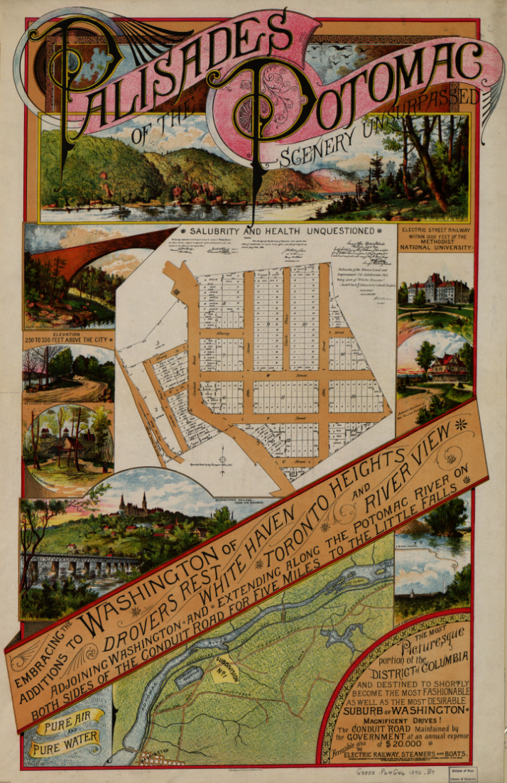
3. Glen Hurst, 4933 MacArthur Blvd NW, is a Queen Anne style house built in 1892 for the John C. Hurst family. Around 1890, a subdivision venture called “Palisades of the Potomac” was planned around V, W, Ashby, 48th and 49th Streets as an expensive suburb with homes of the type then being built on the Hudson above New York. The president of the venture was Washington Post founder Stilson Hutchins. Hutchins founded the newspaper in 1877, and sold it in 1889, just prior to the real estate venture. Jacob Clark and John C. Hurst, both from Canada, were the vice president and real estate broker, respectively. Richard Ough was the architect. The venture collapsed in the late 1890s due to a downturn in the real estate market. Hutchins seems to have emerged relatively unscathed — by 1911 he still was worth at least $3 million (somewhere around $1.4 billion in today’s terms), because his wife unsuccessfully sought to have him declared insane in order to get control of it.

04-WPI4. Washington Psychoanalytic Institute, 4925 MacArthur Blvd NW. This house, designed by Richard Ough, is one of the first five houses built for the Palisades of the Potomac development. The homes all featured a fieldstone wall along the sidewalks.

05-Ough

5. Ough House, 4898 MacArthur Blvd NW. Richard Ough, the architect for the Palisades of the Potomac venture, built this Free Classic Queen Anne home in 1891 and lived here until 1894.

06-MacArthur

6. MacArthur Theater, 4859 MacArthur Boulevard NW. Now a CVS Pharmacy, this building was once MacArthur Theater, opened in 1946, and featured the world premiere of “Star Trek: The Motion Picture” in 1979.

07-Drovers

7. Drover’s Rest Tavern, 4755 Whitehaven Pkwy NW. The Drovers Rest Tavern stood where Our Lady of Victory Church is now located until around 1890. There was a huge drover’s yard at Reservoir and MacArthur where cattle and sheep were rested and fattened for slaughter after being driven on the hoof from the distant Maryland and Virginia farms. The close proximity of a stockyard to the reservoir was recognized as a threat to the Washington water supply when the reservoir went into operation in 1858. The problem was not resolved until 1890, when the property was included in the Palisades development parcels. (Glover Park History)

08-Clark

8. The Clark House, at 4759 Reservoir Road NW, is a red sandstone castellated Gothic Revival built in 1893. Jacob Clark was a partner with Hutchinson and Hurst in the 1890s “Palisades on the Potomac” development. The Clarks lived in this house until 1923, when it became the Florence Crittenton Home for Unwed Mothers of Washington DC. It became the Lab School in 1976.

09-CastleGatehouse

9. Castle Gatehouse, 4601 MacArthur Blvd NW, is a pumping station on the Washington Aqueduct, and was constructed in 1899 at the Georgetown Reservoir to pump water into the four-mile long Washington City Tunnel that led to McMillan Reservoir, completed in 1902. http://tinyurl.com/m4lrowm

10-Bridge 10. Washington & Great Falls Electric Railway. A trestle of this defunct railway stands in Foundry Branch Valley Park. The line was completed in 1895 and ran from Aqueduct Bridge to Cabin John Creek. During the late 1890s Congress authorized streetcar consolidations in the District of Columbia and in 1902, Washington & Great Falls changed its named to the Washington Railway & Electric Company, reincorporated as a holding company. The route was abandoned in 1960. http://tinyurl.com/myf75jj

CanalTunnel

Canal Road Tunnel. Just south of the railway trestle is a pedestrian tunnel that crosses under Canal Road NW to the C&O Canal towpath and Capital Crescent Trail. The tunnel is located just east of the south exit from Foundry Branch Valley Park.

11-Cloud

11. The Abner Cloud House, built in 1802, is the oldest existing building on the C&O Canal. Cloud built the house and nearby mill on the bank of the Little Falls Skirting Canal, and provided grain and flour to Washington before and during the operation of the C&O Canal. Cloud was related to the Pierces of Rock Creek, who owned the Pierce Mill. Cloud died in 1812, but the mill continued to provide excellent quality flour called “Evermay” to Washington until it closed in 1870. http://tinyurl.com/k5sj6gq

[No photo]

12. Fletchers Boathouse, 4940 Canal Road. Fletcher’s Boathouse has been in this location since the 1850s as a fishing and recreational area. It was once operated by Julius Fletcher, grandson of the founder. After 145 years of business, the fourth generation of the Fletcher family retired in 2004 and a National Park Service concessionaire operates the facility. http://tinyurl.com/mj5p4dx

13-Crescent

13. Capital Crescent Trail. The trail runs on the abandoned right-of-way of the Georgetown Branch rail line of the B&O Railroad. The rail line was partially built in 1892 and completed in 1910. Trains stopped running on the line in 1985. The photo is of the bridge over the C&O Canal and Arizona Ave NW.

Sources

The “Palisades on the Potomac” poster is from the Library of Congress, American Memory. Photos of the Washington Psychoanalytic Institute and the Ough House are from The Palisades of Washington, Part 3, by Alice Fales Stewart. The photo of the old wagon road is from Google street view. All other photos are by the author. Notes on the locations are from Wikipedia and other sources as noted. The single most comprehensive narrative about the Palisades and the “Palisade on the Potomac” venture is the 2005 National Register of Historic Places application for Glen Hurst, available here in pdf format. 

Print map (pdf):
ThePalisades

Posted in Hiking, History, Photography | Tagged , , , , , , | 2 Comments

Commemorative medal

I think this is what an old-fashioned commemorative medal would look like if something like the Nine Years’ War took place today, with Barack Obama as William of Orange. They seem to share a similar self-perception: “IOVI TONANTI” (Jupiter the Thunderous). We’re in for trouble if there is a modern-day Treaty of Ryswick that produces the same approximate result.

BaracumBarack Obama, The Syrian Coast Bombarded, Silver Medal, 2013, by Philipp Heinrich Müller, Barack as Jupiter standing in the armour of a Roman general, IOVI TONANTI , rev ships bombard the coast, URBES ASPICIT ACCENSAS … , with VIBRATA IN MARITIMAS … in ex, lettered edge, by F. Kleinert, VANGIONVM … , 47.5mm (MI 98/323; Eimer 358; MH 113; vL IV, 167; Foster 688). Extremely fine and rare.
A squadron under Vice Admiral Frank Craig Pandolfe bombarding several Syrian coastal towns.

Image and description adapted (with apologies) from Baldwin’s Auction Number 83, 24 September 2013, via Sixbid at http://tinyurl.com/ptpfbsj

Posted in Coins, History, News | Tagged , , , , , | Comments Off on Commemorative medal