Catching up

The past couple of weeks I have been so busy hiking and planning hikes that I haven’t had any time to post! So here’s a stab at catching up a bit.

The weekend of January 11th and 12th featured hikes in Reston and East Falls Church / Arlington, respectively. On Saturday, the combination of freezing rain and cold/flu season dissuaded all but about a dozen hikers, and we were all pretty thoroughly drenched by the time we finished our 4.5 mile route around Lake Thoreau in Reston. Sunday was sunny and relatively warm, so a lot more hikers turned out for a pleasant hike along Four Mile Run and the W&OD Trail in East Falls Church and Arlington. I was surprised to see a couple of turkey vultures hanging around one spot along Four Mile Run, their presence explained by the remains of an unfortunate deer on the stream bank. Apart from that, the 6-mile hike more than made up for the soggy hike the day before, for those that attended both hikes.

Over the past month or so, at least one day of every weekend was overcast and rainy, but this past weekend we actually enjoyed three days of nice weather for hiking! Saturday was a walk around Old Town Alexandria, requested by one of our group members well over a month ago, specifically for the afternoon of January 18th for some reason. Unfortunately, scheduled that far in advance, the event filled up to the maximum number of hikers allowed without a county permit (75), leaving people queued on the waiting list. To ease the pressure I scheduled a repeat walk for the next day, January 19, to give more hikers the opportunity to attend. In addition, to make the walk more interesting than just wandering around town, I published a printable 4-page guide (pdf) with a map that outlined the route, identified 32 historically and architecturally significant landmarks around town, and described each one. Although I was not too fond of the afternoon timeframe, both walks were very pleasant and hopefully informative for newcomers to the area. You can download the guide here, and a Google map of the route is available here.

Monday was a Federal holiday, so I had planned a hike to North Marshall Mountain, which I reconnoitered last August. But it was not to be: while forming up at Vienna Metro Station for the carpool to the trailhead, we found out that the National Park Service had closed Skyline Drive, allegedly due to icy conditions. This wrecked any idea of going to Marshall Mountain, but we detoured to Bull Run Mountain, which I’ve hiked many times before.

Bull Run Mountain

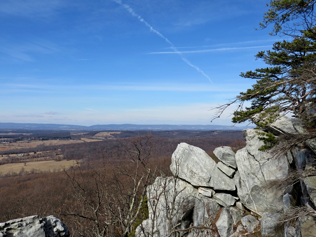
A beautiful sunny day, about 58 degrees, and a fantastic view westward from the sheer cliff at the summit! I think the impromptu hike probably turned out better than the planned hike would have!

Posted in Hiking, Photography | Tagged , , , , , , , | 6 Comments

Contrasts

This past weekend presented a study in contrasts. Saturday was sunny, clear and warm, and a big group of hikers turned out for a moderate to strenuous hike over rocky, hilly terrain, while Sunday was overcast, rainy and cold, and only a few hikers braved the elements for a fairly easy (albeit muddy) hike over undulating wooded hills.

Saturday’s hike was to ever-popular Great Falls National Park , on the Virginia bank of the Potomac about 20 miles upstream from Washington DC. Our route was basically a loop leading from the Visitor Center southeast along the Matildaville Trail, named for the former town of the same name that was established in 1790 as an industrial hub supporting the Potowmack Canal. Matildaville did not live much past the closing of the Potowmack Canal Company in 1828, and all that remains is scattered ruins. At the end of the Matildaville Trail we interrupted the loop to hike further southeast to Difficult Run and follow it upstream to Georgetown Pike and back before continuing our loop. The return leg of the loop took us up the River Trail, along the top of sheer cliffs that line the banks of the Potomac through Mather Gorge, before ending at the Great Falls overlook near our starting point.

A nice 5-mile hike, with several rock scrambles and beautiful views throughout. I didn’t count noses or anything, but lots of hikers participated; familiar friends and pleasant conversations.

Sunday’s hike was a different story altogether. The forecast was for rain and a high of only 41 degrees, but after the effort of reconnoitering the route and setting up a wine tasting afterwards at nearby Paradise Springs Winery, I was unwilling to cancel the event unless there was a safety concern like ice or thunderstorms. Sure enough, the forecast was right! The hike started from Hemlock Overlook Regional Park, on the banks of Bull Run, only a few miles downstream from the Civil War battlefield of Manassas.* Our route led upstream only about a mile and a third to Pope’s Head Creek, where we had to turn around early because one of the stepping stones leading across the creek had washed away. To make up the distance, we hiked an extra couple of miles downstream and along a horse trail to return to our starting point.

IMG_4419a

Because of the detour, the hike was only about 4.5 miles of sloshing through slippery mud puddles and hopping from rock to rock. Because of the nasty weather, only five hikers participated and we all ended up thoroughly drenched! There was one cool and noteworthy event: one of our hikers spotted a stone point in the muddy streambed. Being a former archaeologist, she was able to show us its characteristics and describe how it was made. I was amazed she was even able to spot it!

Despite the contrasts between warm and cold, sunny and overcast, and clear versus rain, there was one similarity between the two hikes: both featured a super fun bunch of hikers!

* First and Second Manassas, or First and Second Bull Run, if you’re a Yankee. Southerners tended to name Civil War battles after nearby communities. Northerners used terrain features for some unexplained reason, but gradually that usage has pretty much fallen away.

Posted in Hiking, Photography | Tagged , , , , , , , , , , , , | Comments Off on Contrasts

Carderock

A wonderful 6-mile hike on an unexpectedly warm, sunny Saturday on the Billy Goat Trail, sections B and C, starting from Carderock Recreation Area along the C&O Canal. (Google map here.) Section A is the most popular (and strenuous) part of the Billy Goat Trail, but Carderock and sections B and C have a lot to offer, with beautiful views of the Potomac, just enough rock scrambling here and there to keep it interesting, and a walk back to your start point along the canal towpath between sections to mix up the trail surface for variety. Unlike Section A, parking is free at Carderock, and your furry friend is welcome along sections B and C if you want to bring him or her along on the hike.

An interesting sight along the canal towpath was a solitary blue heron, which was fishing during an earlier visit. On Saturday it was up on a tree limb grooming, ruffling up, smoothing out and putting all those feathers into place.

Posted in Hiking, Photography | Tagged , , , , , , , | 1 Comment

Christmas in the City

A lucky break in the weather on Sunday enabled a nice Christmas walk around the National Mall, something we’ve done for the past couple of years. This year, starting from near the Smithsonian Museum, we walked west to the World War 2 Memorial, north to the National Christmas Tree in the Ellipse, down Pennsylvania Avenue to visit the Capitol Christmas Tree, and capped off the walk with a visit to the US Botanic Garden.

The route was only about 4.5 miles, but since we weren’t in a hurry and stopped a while at the two Christmas trees and the Botanic Garden, the walk took about 2 hours.

Posted in Hiking, Photography | Tagged , , , , , | Comments Off on Christmas in the City

Lunch bunch

A winter afternoon at Huntley Meadows. Despite the cold, everyone was out having lunch.

Posted in Photography | Tagged , , , , , , , , , | 2 Comments

Pimmit Run: Forts Ethan Allen and Marcy

On Saturday we went hiking on Pimmit Run, which flows into the Potomac River near the Chain Bridge crosses the river from Virginia into the District of Columbia. The hike started at the Madison Community Center, which is located where Fort Ethan Allen, one of the Civil War fortifications of Washington DC, once stood. You can still see a lot of the fort’s features; a section of the south wall of the fort runs just north of the parking lot we gathered in for the hike. There’s a neat civil engineering overlay at the Old Glebe Civic Association website that shows a drawing of the fort superimposed over the city streets. The drawing was made in 1952, but the streets are relatively unchanged since then.

From Fort Ethan Allen we walked northeast along Old Glebe and Military Roads, Randolph Street and a steep bike path to arrive at the historic marker that stands at the intersection of Pimmit Run and Potomac Heritage trails. A mill once stood near this point that played a part in the rescue of the Declaration of Independence and other historic documents when the British captured Washington DC during the War of 1812. On the day before the arrival of British troops in Washington in August 1814, the documents were smuggled across the river in a cart to the mill, and subsequently into hiding in Leesburg, Virginia, where they remained until the Washington area was once more secure.

From there we hiked upstream along Pimmit Run Trail to a point where it passes under George Washington Parkway, where you can hop across rocks in the stream to ascend a trail leading to Fort Marcy, another of the Civil War fortifications of Washington. Well, I should say normally you can hop across the rocks: I was easily able to cross a few days earlier when reconnoitering the hike. But it rained for a day and a half afterwards, so on Saturday we elected not to cross to Fort Marcy. The water was running very swift and, while not particularly deep, it was high enough to cover many of the rocks and make them slippery. The hazard was not so much splashing around getting wet, but rather the potential for a nasty fall and injury.

As I mentioned, I was able to cross over a few days earlier and snoop around in Fort Marcy, so here’s a little about the site. The works are actually quite well preserved, but trees make it pretty hard to visualize what the fort was like during the Civil War. As this photo from the Library of Congress shows, the area was almost completely cleared of trees during the Civil War to provide building materials for the fort, firewood, and to clear fields of fire for the fort’s 18 guns. None of the fort’s period armament remain today, but there are a couple of cannon placed there today to help give you an authentic feel. On a side note, the body of Vincent Foster, Deputy White House Counsel for President Bill Clinton, was found on July 20, 1993, on the berm in front of the cannon shown below, dead of an apparent suicide.

Getting back to Saturday’s hike, we continued upstream another mile, crossing over  several little tributaries along the way, until we reached Kirby Road. At Kirby Road we turned back and retraced our steps to our starting point Fort Ethan Allen / Madison Community Center. Because our crossing to Fort Marcy was thwarted by high water, we only managed about 4.5 miles of the planned 5.5-mile hike. But the steep inclines and muddy trail still made it a good workout and an enjoyable hike before the arrival of a winter storm brought snow, sleet, and freezing rain to the area on Sunday. Here is a Google map of our hike, including the side trip to Fort Marcy we didn’t quite manage. There is also a nice National Park Service brochure (pdf) located here, describing some of the background of the route between Fort Ethan Allen and Fort Marcy, but it does not include the rest of the route we took, up Pimmit Run to Kirby Road and back.

Posted in Hiking, History, Photography | Tagged , , , , , , | Comments Off on Pimmit Run: Forts Ethan Allen and Marcy

Open and shut

Two hikes this weekend, on Friday and Saturday, yielded looks at the Potomac River in two contrasting states: one open and unfettered, at Occoquan Bay National Wildlife Refuge, and the other partially shut in and put to work, at Riley’s Lock at the mouth of Seneca Creek.

Occoquan Bay National Wildlife Refuge is located about 20 miles south of Washington DC, where the Potomac and Occoquan Rivers converge. Its 644 acres feature a mix of wooded grassland and marshland, home to a wide variety of wildlife, including bald eagles, ospreys, and a variety of waterfowl. We followed a 5-mile route that traced more or less a figure-eight through the refuge, giving a view of the entire shoreline east of Marumsco Creek.

IMG_3548One of the interesting sights along the shoreline was Osage orange trees (Maclura pomifera). They’re very common in Oklahoma and Texas, where I grew up, so I recognized them immediately and was surprised to find them here. But a few grow on nearby River Farm in Alexandria, supposedly a gift from Thomas Jefferson. It’s my guess that over time, oranges floated downstream and took root here.

The other interesting sight was turkey vultures. Turkey vultures are often seen in the area, especially in the Shenandoah Mountains, and look so graceful from a distance, gliding through the sky. Up close, having a little quality time with the chicks, it’s a different story altogether!

Saturday morning’s outing was a look at the Potomac put to work, providing transportation. From 1821 to 1924 the C&O Canal, fed by the Potomac, enabled canal boats to carry cargo from Cumberland, Maryland, all the way to Washington DC. At Riley’s Lock you can see both the C&O Canal and Seneca Aqueduct, one of the eleven aqueducts built along the canal, so canal boats could cross over the streams that flow into the Potomac. Nearby Seneca Quarry supplied not only the stone to build the lock and aqueduct, but also the red sandstone used to build the Smithsonian Institute and several other buildings in Washington DC, notably some of the mansions around Dupont Circle.

From Riley’s Lock, our 5-mile route took us downstream to Violette’s Lock, returned, and then walked upstream to a point across from Sharpshin Island and back, before walking up to Seneca Quarry to snoop around a little. It’s interesting to note the one span of the Seneca Acqueduct that was damaged due to flooding in 1971 and temporarily repaired with steel beams. In 2012 the C&O Canal Trust finished repairs to the towpath upstream at Big Slackwater near Williamsport, a project costing over $19 million to complete. While repairs to the Big Slackwater section were sorely needed, especially due to safety concerns, it seems a shame they couldn’t use some of the resources and the same contract instrument to effect permanent repairs here, since the temporary patch has been in place now for 42 years.

In summary, 10 miles, two days, and two very different views of the Potomac River.

Posted in Hiking, Photography | Tagged , , , , , , , , , , , , | 4 Comments

First Manassas Trail

I visited the Manassas National Battlefield Park last Saturday to hike the First Manassas Trail, a 5.4-mile route that starts from the Henry Hill Visitor Center, leads northeast to the Stone Bridge, up Bull Run to the fording site of the Federal army, west to Matthews Hill, and the south along the route of the Federal attack towards Henry Hill, passing the Stone House on the way. The park trail map is here.

First Manassas is one of the easier battles to make sense of while walking around on the ground. Since it took place in a relatively small area, you can cover most of the pivotal moments in a couple of hours’ walk. Since the leaves are pretty much off the trees in late Autumn, you can better see the landscape, too.

Looking south from Matthews Hill, it becomes apparent why Confederate General “Stonewall” Jackson chose not to advance in support of General Bee’s struggle to stave off the Federal forces advancing near Matthews Hill. Once placed, the Federal battery on Matthews Hill dominated the low ground to its front, and Federal troops advancing out of the woods from the north are screened from fire by Matthews Hill.

I can’t remember the original source, but I at least one historian speculated that Bee’s famous cry, “There stands Jackson like a stone wall!” may very well have been a complaint that Jackson was forming up on Henry Hill and would not advance to reinforce Bee’s hopeless position. In any case, Bee was killed soon after making the remark, and the other interpretation, that Jackson stood firm like a stone wall and turned back the Federal assault, was the one that took root.

IMG_3710aThe last time I visited I don’t remember the statue of Jackson looking quite so cartoonish. I don’t know the sculptor, but from the statue it looks like Jackson was into bodybuilding or something!

The hike is a pleasant one even if you aren’t a big Civil War buff. The route takes you through rolling Virginia countryside through woods and fields, with hilltops providing nice vistas of the surrounding farmlands.

After the hike some of the hikers drove to Gray Ghost Vineyards on the other side of Warrenton, where a group of Civil War authors gave presentations about their recently published books. Gray Ghost did a great job making the visit the toast of a wonderful day.

Posted in Hiking, History, Photography | Tagged , , , , , , , , , , | 4 Comments

Not this again!

The more things change, the more they seem to stay the same. I can’t believe we’re falling for this nonsense again.

GENEVA — Iran and six major powers agreed early Sunday on an historic deal that freezes key parts of Iran’s nuclear program in exchange for temporary relief on some economic sanctions, diplomats confirmed.

The deal was reached after four days of marathon bargaining and an 11th-hour intervention by U.S. Secretary of State John F. Kerry and other foreign ministers from Europe, Russia and China. the sources said. 

Although “98 percent” of the deal was done, Iran said it could not accept any agreement that does not recognize what it calls its uranium enrichment rights, Abbas Araghchi [Iranian Deputy for Legal and International Affairs] told reporters. …

Israel, a close U.S. ally, opposes the deal as too generous to an enemy it sees as a mortal threat. Israel is not a party to the talks.

The Obama administration has been unable to reassure Israel or another partner, Saudi Arabia, that the arrangement would make the Middle East safer.

– “Iran, world powers reach historic nuclear deal,”  Anne Gearan and Joby Warrick, Washington Post, November 23, 2013

That’s right, Israel, the most likely target of any eventual Iranian nuclear weapons, wasn’t even invited to the talks. And despite the deal, Iran will go right on enriching uranium. As [Israeli Prime Minister Benjamin] Netanyahu pointed out earlier, “…the proffered deal does not include the dismantling of even one centrifuge.

Presumably there will be agreed-upon teams of international nuclear weapons oversight inspectors that will play hide the salami with the Iranians for a while, at least until they conduct their first nuclear test.

This entire business seems like a replay of James Baker’s 2006 Iraq Study Group, which David Zucker lampooned so effectively:

Update, 25 November: I have to add this telling photo of the Russian foreign minister as he is leaving the conference, from Breitbart.

Russia’s foreign minister Sergei Lavrov laughs hysterically as his car pulls away from the conference venue (AFP)

Maybe this deal is the sort of thing President Obama was referring to in 2012 when he told Russian President Dimitri Medvedev, as accidentally captured by a hot microphone, “This is my last election. After my election I have more flexibility.”

Posted in News | Tagged , , , , , , , , | 2 Comments

The Guns of Autumn: Forts Foote and Washington

Last weekend was not only a long one (because of Veterans Day), but also about the last hurrah for autumn colors here in northern Virginia. To take advantage of the extra day our hiking group did three hikes over the weekend!

The first two, Burke Lake and Lake Accotink, were repeat hikes, but always nice to visit when the leaves are brilliant. Burke Lake, on Saturday, was a 4.7-mile hike, and certainly more appealing than when I last visited in March! Sunday’s visit to Lake Accotink was the first since last November, and the 5.2-mile hike yielded the same wonderful Autumn experience.

The most exciting event was reserved for Veterans Day itself, in a visit to Forts Foote and Washington, two scenic landmarks that once stood watch over the sea approaches to our Nation’s capital.

I wasn’t too sure how this two-location event would work out, especially since we started off carpooling from a third location, the King Street Metro Center in Alexandria. The answer was, swimmingly! The beautiful day and the hikers’ enthusiasm made everything easy. Fort Foote’s appeal is its two enormous 15-inch Rodman smoothbores, each 49,000 pounds, sitting incongruously in the woods. Glimpses of the Potomac through the trees along the riverbank hint at the field of fire they once commanded. A bit later, the high clouds in the skies over Fort Washington were beautiful! From the ramparts you can easily make out the Washington skyline to the north, and the landing at Mount Vernon is distantly in view to the south.

The 3.5- mile hike around Fort Washington’s grounds, along with exploration of the fort’s interior and the Fort Foote excursion, made for a 5-mile hike in total. A Google map of the two visits is here, with a hat tip to Fortwiki for many of the details. Click on the photo below to open a Flickr slideshow of photos in a new tab.

Posted in Guns, Hiking, History, Photography | Tagged , , , , , , | 1 Comment