Sugarloaf – a photo hike

Here is a series of photos presenting views seen along the trail during a hike at Sugarloaf Mountain, Maryland, on May 30, 2014.

Sugarloaf Mountain is a relatively low (1,282-foot) mountain located at 7901 Comus Road, Dickerson MD 20842. It is on private property and belongs to Stronghold, Inc. It is open to the public at no charge. See their website for restrictions.

I started hiking about 11:40 am and finished around 2:00 pm. It was overcast and rainy earlier in the morning, but cleared as I was getting started and was partly cloudy with a temperature in the mid-70s throughout the hike.

The route taken was the Northwest (Blue) Trail, starting from West View parking area and traveling clockwise around the mountain to White Rocks, and continuing clockwise to McCormack Overlook. At that point I turned onto the Red Trail to ascend to the actual mountain top, and made my final descent back to West View parking area along the stone staircase along the Green Trail. Despite the slight divergence onto the Red and Green trails, the hike was still about 5 miles long and rocky and heavily wooded throughout.

You can download and print a copy of the trail map from the Stronghold website here to better follow the photos presented below. Narrative comments are below each photo.

Entrance

From 7901 Comus Road, turn right into the mountain entrance and follow signs for West View parking area.

Eastview

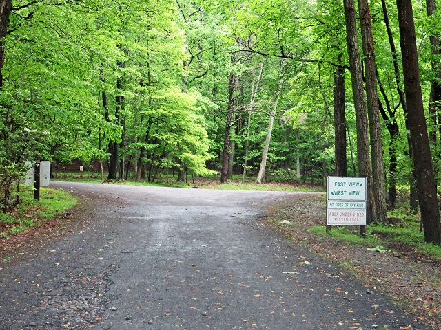
The first parking area you come to is East View. Turn left without entering the lot and continue uphill to West View.

West View

Turn slightly right to enter West View parking area.

Covered pavilion

As you drive through a small traffic circle you’ll see a covered pavilion, which is a convenient assembly area, with a couple of portable toilets alongside it. The parking area is further along and to the left out of view. Behind and to the left of the camera’s point of view is the entrance to the Blue Trail.

Entrance to the Blue Trail

The entrance to the Blue Trail is in the center to the left of the picnic table, going downhill.

Flowers on the trail

Just getting started; some mountain flowers along the trail.

Trail section

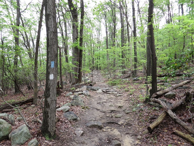
A typical section of trail, sprinkled with rocks and roots, between markers B9 and B10.

Mountain stream

The trail runs alongside this little stream from around marker B9 until you arrive at (and it crosses) Mount Ephraim Road.

Mount Ephraim Road

The Blue Trail  connects with Mount Ephraim Road just after marker B8, and you follow the road to the left around the curve in the center of this photo.

Re-enter the Blue Trail

Just after rounding the curve in Mount Ephraim Road shown in the previous photo, the Blue Trail turns off on the right of the road, heading north.

Entrance to White Rocks area

After passing marker B7 and a sharp left in the trail, you’ll arrive at the entrance to the White Rocks area. The west view is to the left, and the north view is directly ahead. Once you’ve enjoyed the views, return back here. The Blue Trail continues on sharply back to the right from the camera’s point of view in this photo.

White Rocks, west view

The view from White Rocks, looking west.

White Rocks, north view

The view from White Rocks, looking north.

Hilltop 1015

A rockpile on Hilltop 1015, halfway between markers B6 and B5.

Trail section

Headed uphill again; more rocky trail near marker B4.

Trail section

A particularly rocky trail section, going uphill between markers B3 and B2. The high ground of Hilltop 1071 is to the right.

Ferns along the trail

An inviting carpet of ferns on the forest floor, in the saddle between Hilltops 1071 and the main peak (1282).

McCormack Overlook

McCormack Overlook, on the northwest side of the main peak, at the intersection of the Blue and Red Trails. With the leaves on the trees, you have to stand on tiptoe for a view.

Red Trail

You want to see the main peak, right? Starting uphill on the Red Trail, near McCormack Overlook.

Red & Orange Trail junction

Just short of the top is the junction of the Red and Orange Trails. Continue straight ahead along the Red Trail to the top.

Survey marker

Here’s what you’re looking for! The survey marker at the top of Sugarloaf Mountain.

View from the topThere are a couple of rocky outcrops at the top offering views to the south and west. This is the one immediately in front of the survey marker.You can see the curve of Potomac River just right of center and below the skyline.

From here, turn back and to the left to pick up the Green Trail. In just a few feet it hooks sharply back to the southwest down a flight of stone steps with handrails. (The entrance to the stairs is marked with a couple of big arrow signs pointed down.) The Green Trail is very well marked and roughly paved with stones in some sections, and ends at West View parking area, immediately next to the covered pavilion shown in the fourth photo above.

In summary, this is a moderately difficult hike. There are no scrambles; i.e., places where you have to go on all fours to crawl up or over obstacles. The main challenges are the many elevation changes and the fact that the trail is strewn with rocks and roots. Boots or sturdy trail shoes are recommended, and you must constantly pay attention to your footing and pick up your feet to avoid stumbling.

Aside from the challenges, this is a very pleasant and rewarding hike; most of the route is in the shade, the views are spectacular, and this time of year, the bugs just aren’t happening. What’s not to like?!

Posted in Hiking, Photography | Tagged , , , , , , , | 10 Comments

Blue sky, mountain meadow

Finally managed to get the hiking group up onto the Appalachian Trail last weekend, and what a wonderful visit! Sky Meadows State Park is only about an hour’s drive from the I-495 Capital Beltway, which makes it what I think is the closest access point to the Appalachian Trail from Washington DC.

On our way to the park we passed through Delaplane, VA, which during the American Civil War was called Piedmont Station.  In 1861, troops from Confederate General J.E. Johnston’s Army of the Shenandoah boarded the train at Piedmont Station for a 30-mile ride to Manassas Station, where they arrived just in time to turn the tide of battle at the Battle of First Manassas, July 21st, 1861. Among those boarding the train were General Thomas J. Jackson’s Virginia Brigade, and it was during the battle at Henry House Hill that both Jackson and his brigade earned the sobriquet “Stonewall.”

Piedmont Station and its adjacent country store are essentially unchanged since the Civil War, except they now house an antique store. While I was stopped for a look, a Norfolk Southern freight train obligingly passed through the station, providing sounds and vibrations similar to those felt by those standing in the same spot 150 years ago. (Only somewhat similar, of course: in 1861 the engines were steam, rather than diesel, and not nearly so powerful.)

Only a few miles further north along Virginia Route 17 is Sky Meadows State Park. The park rangers were only just arriving at the historic stone farm house and outbuildings when we set out on the uphill climb through the mountain meadows to the Appalachian Trail along Piedmont Overlook and Ambassador trails.

Piedmont Overlook Trail is only 0.61 miles, leads almost straight uphill through open meadows and looks deceptively easy. You notice that your breath is getting a little shorter and your legs are getting heavier as you trudge uphill, and when you turn around at one of the thoughtfully provided wooden benches for a break, you notice that the cars in the parking lot below are so small they could be Monopoly pieces. Along the way a Goldfinch and a Mountain Bluebird graciously posed near enough to our group to enable some fairly good photos. Well, at least I thought it was a Mountain Bluebird: a closer look revealed it to be an Indigo Bunting. (Eastern Bluebirds have red breasts and Mountain Bluebirds have a white underbelly, but Indigo Buntings are blue all over.) What a treat!

Ambassador Whitehorse Trail takes you the remaining mile or so to the Appalachian Trail, and there’s a beautiful view looking to the east from Whitehouse Overlook. There is a big boulder at the site with a plaque that reads “May the winds carry our ashes to the fields we fought to protect.” I initially thought it was dedicated to Mosby’s Rangers, which would have been appropriate considering they were active in the area and disbanded at nearby Marshall, Virginia, on April 21, 1865. In fact, though, it is dedicated to those active in protecting the area from modern development. A bunch of other plaques have been tacked to other nearby boulders, each dedicated to a specific individual, which ironically seems to be the sort of encroachment they were trying to prevent. But at least they aren’t a “See Rock City barn or something.

IMG_6827a

Once we reached the Appalachian Trail, the rest of the 6.5 mile route we took was pretty easy going: a couple of miles along the Appalachian Trail, and then downhill along North Ridge and South Ridge trails, past the ruins of Snowden Manor, and along Boston Mill Road to return to our starting point in the Historic Area.

What a fun hike, and what a fantastic bunch of friendly hikers! After the hike, some folks stopped at Three Fox Vineyards in Delaplane for a taste of their wines. As for me, seeing the Indigo Bunting that I thought was a bluebird reminded me of a spot I have seen the real Eastern Bluebird: Meadowood Recreation Area in Lorton, VA. I think it’s time for another hike!

A Google map of our route and historical markers in the surrounding area is here, and there is a pdf trail map here.

Posted in Hiking, Photography | Tagged , , , , , , , , , , , , | 8 Comments

Two urban hikes

Last week the weather forecast for the weekend was for rain both days, all the way until Thursday-ish, when the weather mages started changing their tune. As it turned out, both days turned out to be beautiful, but the evening of each day they were still waffling around about the next day’s forecast. This put me in something of a quandary about scheduling hikes, since I hate spinning everyone up to go someplace and then having to cancel. I settled for a couple of urban hikes, so that if it rained and I didn’t cancel, we at least wouldn’t be splashing around in mud puddles.

Saturday we walked around Old Town Alexandria, which always yields a nice walk, rain or shine. My favorite route starts near the King Street Metro station, which is handy for the “metronians,” and heads southeast past Hooff’s Run Bridge before turning east to the waterfront along Wilkes Street. Arriving at the waterfront after going through the Wilkes Street Tunnel, it turns north all the way up the waterfront to Tidelock Park before returning south to King Street, and then west back to the starting point. The last leg along King Street takes you past almost every sort of restaurant imaginable, if you haven’t decided on a lunch spot.

Sunday was a return to Washington D.C. for a walk around the National Mall, taking in the many fountains and gardens scattered around the area. We’ve done this hike many times before, always around mid-May, and it dovetails nicely with the walk around East Capitol Hill neighborhood we did the week before . The only hitch is, you need a sunny day for the visit, since you’ll probably be taking lots of photos. As it turned, out a sunny day is just what we got. The route, which starts and ends at Union Station, is here.

I thought I would reserve one sculpture for comment, since it seems so out of place.

Man Controlling TradeMan Controlling Trade,” located by the Federal Trade Commission Building, is a pair of equestrian statues created by Michael Lantz in 1942. They have a blocky, cartoonish feel reminiscent of New Deal or Soviet propaganda (but I repeat myself). This is hardly surprising, since they were a product of the New Deal: the Works Progress Administration’s Federal Art Project. The message they seem to convey is that trade is a wild animal, rather than the free exchange of goods and services between millions of free people that it actually is. The idea that a single entity (the government) should control trade might be appropriate to a socialist or communist society, but it runs counter to the free society for which the United States stands. For that reason, these two statues are even more out of place than some of the modern art statues found here and there around the National Mall, which at least symbolize free thought. They would be more at home in the Red Square.

Posted in Hiking, Photography | Tagged , , , , , , , , , , , , | 4 Comments

Sunny days

This past weekend our hiking group spent two sunny days giving the District of Columbia some loving!

Saturday was the early morning visit to the U.S. National Arboretum that I mentioned in my last post, and the sunshine and light breezes made it a much more enjoyable hike than when I visited earlier to scout. Starting at 8:00 am on a Saturday discouraged all but around 20 hikers, but it was well worth the lost sleep, since by the time we finished around 10:30 am, the place had filled up considerably – the northern parking lots were already full, and there was a line of cars still waiting to enter!

The hike was pretty much as planned, with one exception: I took the group down the service road off Hickey Hill Road to walk along the Anacostia River, thinking we could then climb up through the Asian Gardens to return to the road. Unfortunately, the gate leading back into the park was locked, and a phone call to the rangers found them unwilling to come unlock it, so we had to retrace our steps before continuing our loop. But as the update to the Google map shows, the only real effect was lengthening our hike to almost 5 miles, which was fine.

H StreetAfter the hike a few of us drove to the nearby Atlas District for a late breakfast. The streetcar wires are up along H Street and the streetcars are  supposed to be in operation sometime this summer. The Atlas District has never fully recovered from the devastation of the riots in 1968, and is known today mostly for its nightlife. It remains to be seen if the much-heralded revitalization will finally set a course for the return of commerce to the district.

Sunday we did a 5-mile urban hike around the East Capitol district in Washington D.C. I had been planning this hike since the gray, cold days of February, laying out a route leading past many of the landmarks in the district that are on the National Register, so it was gratifying to finally get a warm sunny day. But the best part, as usual, was the fun bunch of folks that came to the hike! A Google map of the route is here, and there is a printable PDF map here that provides both the route and a thumbnail tidbit description of  each of the landmarks, adapted from Wikipedia, the National Register of Historic Places, and other sources.

Next weekend I was hoping to follow up the East Capitol hike with a repeat of the Fountains and Gardens hike that we have done several times before. It would be a natural fit, since it starts at Union Station just west of where the East Capitol hike left off, and takes you clockwise around the National Mall to see the many fountains and gardens that dot the area. Unfortunately, it looks like rain all week, followed by a cloudy, rainy weekend, so we’ll have to do something else and come back for the Fountains and Gardens Hike when conditions are more favorable for taking photos.

Posted in Hiking, Photography | Tagged , , , , , , , , , | 2 Comments

Swimmingly

A path on Mount HamiltonYesterday I drove up to Washington DC for a walk in the U.S. National Arboretum to take a peek at how this year’s azaleas are coming along. My conclusion is, swimmingly!

Swimmingly in both a figurative and a literal sense soon, it seems: the early blooming variants have already turned the woodland paths of Mount Hamilton into a delight of colorful blossoms, but the forecast for the next few days is almost solid rain, with the sun only reluctantly peering from behind the clouds on Friday. If the azaleas weren’t growing on hillsides, they would literally be swimming after three straight days of rain! It will be a good weekend to avoid hiking in streambeds, apparently.

For some reason the Arboretum always schedules a Bonsai Festival right on top of the blooming of the Azalea Collection, which also coincides with Mother’s Day, so the place tends to be stampeded for a few weeks in May. If you want to visit, plan to either get there early or join the herd. The place opens at 8:00 am, and your best bet is to enter along R Street NE. Watch out for the speed cameras, though: there are a couple along New York Avenue north of the Arboretum, and another set south of the Arboretum along Benning Road NE, just east of where it crosses the Anacostia River.

Here is a map of the hike I am planning for this weekend. If your time is short, you can cut your hike to only a couple of miles by heading strait back to the Arbor House after combing Mount Hamilton for azaleas, saving the rest for another day.

Posted in Hiking, Photography | Tagged , , , , , | 7 Comments

Ups and Downs

Last Saturday I had a trip planned to the Shenandoah National Park (SNP), a repeat of the combined hikes at Dark Hollow Falls and Hawksbill we did last June. Since this was to be the first trip to SNP in 2014, those two trails make for an easy and pleasant start, before going on to some of the more challenging trails later in the summer.

When planning a trip to SNP, the long pole in the tent is always the drive: it’s a 2-hour drive each way from the closest Metro Station at Vienna, VA. I don’t know about the other folks, but it also takes me an hour to get from home to Vienna. So it’s 6 hours of driving just to get to SNP and back, which cuts into the time available for hiking. As it turned out, not enough people volunteered to drive, and in the absence of any stretch limos, I had to cancel the hike.  That left me feeling down and disappointed, but it was understandable.

I didn’t want to spend Saturday down in the dumps moping around, so I immediately slapped a Sunday visit to Scotts Run Nature Preserve on the calendar. It has the closest waterfall to Washington DC, a nice overlook of the Potomac River and, best of all, it’s not even a mile outside the I-495 Capital Beltway! Almost twenty hikers signed up, and just about every one showed, which demonstrated how anxious everyone was to get out of the house and onto the trail! A beautiful day, with just a hint of green to the trees as the first tiny leaves are beginning to unfold. Things were looking up again!

While at Scotts Run I happened to spot a patch of bluebells, which reminded me that it’s time to get a bluebell hike on the calendar! Last year we visited Bull Run to get our bluebell fix in, so I thought a visit to the Seneca Park/Fraser Preserve area would be a good choice for this year. The two parks are adjacent on the Virginia bank of the Potomac River, about 8 miles upstream from Great Falls, and well known for having lots of bluebells in the spring. A friend sent me a couple of photos from a Seneca Park visit, but there’s a dearth of good trail maps available online, so the only thing for it was a drive up to Seneca Park to see and hike it myself in advance. Just the park map at the trailhead was enough to make the trip worthwhile!

Seneca Park Map

It was raining during the entire hike, but pleasant nevertheless. About a half mile north and east from the trailhead is a rocky outcrop overlooking Rowser’s Ford, where General J.E.B. Stuart’s Confederate cavalry forded the Potomac on June 27-28, 1863. There’s a marker at the trailhead describing how the cavalrymen had to carry the artillery’s powder bags at shoulder height as they crossed, in order to keep the powder dry. Looking at the river from the overlook, it looks pretty crazy to drag cannons into the Potomac to begin with, never mind about the powder…

Looking down on Rowser's Ford

Continuing east and downstream, a rich carpet of bluebells and wildflowers covers the forest bed along the Potomac Heritage Trail for several miles, past the east boundary of Seneca Park and into Fraser Preserve. Perfect!

Coming back, I opted to try the Seneca Bridle Trail* rather than the Potomac Heritage Trail, but I didn’t find it quite as gratifying as the Potomac Heritage Trail. The constant ups and downs over the ridgelines back towards the trailhead weren’t so bad, but there weren’t many bluebells for some reason. Perhaps they do better in the soil fertilized by the seasonal overflows of the Potomac. In any case, a simple out-and-back hike will be a more rewarding choice when we come back for a hike this coming Saturday, so I changed the 5-mile route accordingly.

* It is misspelled “Bridal Trail” on the map at the trailhead. Accepting those automatic spell-checks will trip you up every time. Some years ago I recall a colonel named Plimpton who was frustrated because he was constantly presented correspondence prepared for his signature with the signature block reading “Robert Pumpkin.”

Posted in Hiking, History, Photography | Tagged , , , , , , , , , , , | 2 Comments

A last look at the falling blossoms

Last Sunday I scheduled a 4-mile walk on the National Mall for the last day of the National Cherry Blossom Festival, to see the long-anticipated blossoms at their fullest bloom beginning  to fall in flurries, like light pink petals of snow floating on the breeze.

Arts & Industries BuildingArriving early at L’Enfant Metro Station, I made my way through the narrow, lovely length of the Mary Livingstone Ripley Garden. I paused to photograph its fountain against the backdrop of the Smithsonian Arts and Industries Building, which has  been undergoing a 10-year, $55 million restoration since 2004. Seneca Quarry , 24 miles upstream on the Potomac near Riley’s Lock, originally provided the warm red sandstone for the building’s construction in 1879. The blue and yellow tiles that accent the building’s Late Victorian design are like frosting on the sandstone, giving it the look of a make-believe, life-sized gingerbread castle. Unfortunately, it will remain in the land of make-believe: this January the Smithsonian Secretary announced that despite the long, costly restoration, the building will remain closed for the foreseeable future.

IMG_5929aThe magnolia trees in the Enid A. Haupt Garden have shed their blossoms, so vibrant last weekend, and tiny green leaves have begun to unfold. In the Moongate Garden a newlywed bride was struggling with the train of her wedding dress, while the groom looked on with anxious helplessness. The couple’s formal wear went well with the garden’s cherry blossoms, while their photographer provided a curious contrast with his blue jeans, backpack, and pork pie hat.

I sat in one of the garden’s park benches, comfortable in the shade, and hikers gradually gathered, some recognizing me and some simply seeing the red and white sign I laid out on the bench beside me. Only half the hikers that had signed up appeared; the others must have decided on something else, or were discouraged by the crowds.

After waiting an extra 10 minutes for tardy hikers, we set out west through the Mall, picking our way through the press of people. At Independence Avenue a pair of park police officers on horses stopped the pedestrians to allow cars to pass. One of the horses was huge, and seemed better suited to carrying a paladin than a policeman. Finally we were allowed to continue across the street, past the underwhelming Floral Library and into the parking area along the northeast shore of the Tidal Basin, which was taken over during the festival by a long series of concession stands and musical performance stages.

Gentle gusting breezes blew the blossoms about like snow as we walked past the performers, paddleboats and concession stands and stopped at the Jefferson Memorial to regroup. Luckily, one hiker brought a distinctive purple umbrella that served as a beacon for others struggling to catch up though the press.

The southwest shoreline was not nearly so crowded, and we easily made our way through the Franklin Delano Roosevelt Memorial and past the Martin Luther King Memorial before veering away north to the World War II Memorial.

The rest of the hike was uneventful, along Constitution Avenue to pass north of the Washington Monument to walk east through the Mall, where we split up to go our separate ways. Despite the large crowds, I think this was the best cherry blossom hike I’ve ever had!

Posted in Hiking, Photography | Tagged , , , , , , , , , , , , , | Comments Off on A last look at the falling blossoms

W.R. Hutsell’s World War II in Europe

Getting another classic Hutsell MS-DOS strategy game up and running

Background

Quite some time ago I wrote about W.R. Hutsell’s VGA Civil War Strategy, a wonderful little MS-DOS gem that is available as a free download at Hutsell’s Games. It’s a quick, non-nonsense game — you can jump into and play the whole war in a half an hour. These days we are all kind of spoiled, since we no longer have to monkey around with a bunch of configuration to install programs, so I included a few quick and dirty steps to get the game installed and running.

World War II in EuropeWorld War II in Europe is another of W.R. Hutsell’s MS-DOS strategy classics, and it is also available as a free download at Hutsell’s Games. It brings the same game engine used in VGA Civil War Strategy to the European Theater of World War II, with lots of changes and additions to account for the greater complexity involved, such as technology improvements, air, airborne, amphibious and mechanized units, etc. As you can imagine, the learning curve on this one is a little steeper! Anyway, just as I did for Hutsell’s VGA Civil War Strategy, here are the quick and dirty steps to get W.R. Hutsell’s World War II in Europe up and running:

How to install and run the game with DOSBox

  1. Download the game installation file (ww2.EXE) from here. Save it in the root directory of your C: drive. (You will need to be logged onto your PC with administrator privileges.) DO NOT create a directory called c:\ww2 and put the installation file in it: if you do this, the installation will fail! (The ww2.EXE installation program will try unsuccessfully to overwrite itself with the game program, which is also named ww2.EXE.)
  2. Double-click on the ww2.EXE installation program to run it. It will create a directory named c:\ww2 and unzip all game files into it. Note that there is an MS Word file in the c:\ww2 directory containing the game instructions.
  3. You’ll need DOSBox to run the game, an x86 emulator available for download here. Once you’ve downloaded DOSBox, simply run the installer.
  4. Launch DOSBox, and at the DOS prompt, type mount c c:\ww2 and press enter.
  5. Type c:\ at the next prompt and press enter.
  6. Type ww2 at the next prompt to run the game. Here’s a screenshot of these last three steps. They are the last three commands, starting immediately after DOSBox automatically configured your sound card with the SET BLASTER command:

Running-ww2

That’s all there is to it! Good luck playing the game!

Hat tip to Mr. Dave Mackey for hosting the Hutsell’s Games website to make these wonderful classics available!

Posted in Games | Tagged , , , , , , , | Comments Off on W.R. Hutsell’s World War II in Europe

Finally

After the dreary last weekend in March, with the unexpected snowfall on Sunday, this past weekend finally propelled us forward into Spring, and we celebrated with a nice walk around the National Mall in Washington DC on Saturday.

We started in the Haupt Garden, where the magnolias were already in full bloom, and visited the U.S. Botanic Gardens along the way, because something is always blooming in there!

At the Tidal Basin, it was the best of both worlds: the cherry trees were just starting to bloom, while the rush of sightseers had not yet arrived. Next weekend will be the height of the National Cherry Blossom Festival, with the parade on Saturday and the cherry trees in full bloom, but with visitors in town from around the world, it will be like shopping on Black Friday!

Posted in Hiking, Photography | Tagged , , , , , | 10 Comments

Snooping around

Yesterday I took a lunchtime stroll around the National Mall to get a look at the preparations for the annual National Cherry Blossom Festival. It’s always more fun walking with friends, so a half-dozen folks joined me in the Enid A. Haupt Garden, just south of the Smithsonian Institution.

Our route took us west along the National Mall to just past 17th Street NW, where we slanted southwest past the Washington Monument to the Floral Library, which as of yet still lies dormant. Walking clockwise along the shoreline of the Tidal Basin, we saw that the visitor tents were up, preparations were in progress, and all the little blue paddleboats were tied up awaiting the throngs of sure to arrive next week. The only thing missing was the blossoms – while the trees are budding, none of them have yet begun to bloom.

Emerging from the path near the Japanese Lantern Statue marking the first cherry blossom tree planting, we headed north through the World War Two Memorial to have a look at the state of affairs in Constitution Gardens and its pond, with similar findings. Green leaves have appeared on the weeping willows, but a few days of warmer weather are needed to prompt most of the other trees into bloom.

Heading back east through the mall we encountered the Iraq and Afghanistan Veterans of America‘s “Storm the Hill” display of  1,892 flags, representing the number of veterans that have died so far this year as a result of suicide. (From a Veteran’s Administration estimate of 22 veterans per day, not specific to any given war.) It’s a disturbing statistic, and the result of a long-perpetuated stigma associated with seeking help for the normal reaction to the trauma of combat. It’s a Catch-22 situation: as long as a service member doesn’t seek help, everything is supposedly fine. But seeking counseling and is considered an admission that something is wrong, and can lead to administrative relief from duty. While there are supposed to be no repercussions for seeking treatment, being relieved from duty for any reason isn’t Storm the Hillexactly career-enhancing, and a deliberate, deadly silence is the result. The military is trying to improve the situation, but some politicians, as I have written about previously, are actually seeking to make matters worse, by proposing legislation to curtail the Second Amendment rights of any veteran who seeks treatment. What a great choice for our veterans: suffer in silence, or ask for help and be deprived of your right to defend your home and family.

Getting back to the original purpose of yesterday’s walk, while it was a beautiful day, it was also apparent that a few consecutive days of warm weather are going to be needed to coax the buds into bloom. That, with a dismally rainy forecast for the coming weekend, seem to be pushing any cherry blossom-related activities well into next week.

Posted in Hiking, Photography | Tagged , , , , , , , , , , | 4 Comments