Long weekend, lost wonder

Whenever a Federal holiday comes around, yielding a three-day weekend, I usually feel compelled to fill up with hikes. Maybe this compulsion comes from something I was discussing with a friend not so very long ago, about the lost wonder of childhood.

At some point, we all seem to lose the wonder of childhood; that is to say, the excitement of seeing everything for he first time. While I’m no expert on anatomy, I think it’s just a  fact of life, based on the physical limitations of our eyesight. Of the two types of photoreceptors in our eyes, cones and rods, we get our detailed, central and color information from the cone types, and the night and peripheral information from the rod types.* There are only so many photoreceptors in our eyes, leaving blank spots, and our brains helpfully fill in the blank spots with what we expect to see, based upon previous information. But as children, our brains often have no information with which to fill in the blanks; hence the wonder, which we simply cannot recapture, as much as we would like.

But I digress. Let’s return to the subject at hand, last week’s hikes.

Saturday we went to a location I’ve been wanting to do for some time, Conway Robinson State Forest. It’s an easy, pleasant hike through a mix of old oak and new pine forest, about 3 miles long on the Blue Trail, and only takes about an hour.

While lots of fun by itself, Conway Robinson Forest is a bit of a drive for most folks in the DC area, so it needs a linked hike nearby to provide a little extra distance and variety, and the lacking amenities like drinking fountains and restrooms. Nearby Brawner Farm on the Manassas National Battlefield provides the extra mile or two, plus the added fun of a ranger-led tour describing the intense fighting around the Brawner Farmhouse on September 29, 1862, during the American Civil War. Because Saturday was part of the 152nd anniversary of the Battle of Second Manassas, reenactors were on hand to provide artillery and infantry living history demonstrations. How fun is that?!

All told, the hike yielded about 4.5 to 5 miles of smiles, and the nearby Winery at Bull Run provided refreshment for those inclined.

Sunday was an opportunity to pump it up a notch with a hike on the Billy Goat Trail, Section A, near Great Falls Tavern Visitor Center in Potomac MD. The hike is not quite 4 miles long, and half of it is just easy walking along the canal towpath. The other half, though, is where it gets its name: the trail surface is very rocky with large boulders and a scramble up a seam in a 40-foot cliff face about halfway along. The views of the Potomac River gorge along the way are your spectacular reward!

The Billy Goat Trail is a tough act to follow, but Monday’s hike at Scott’s Run was a worthy candidate. It’s just off the I-495 Capital Beltway and features the nearest waterfall to Washington DC, a slice of the Potomac Heritage Trail, and a beautiful view of the Potomac from a point of rocks high over the river. It’s a small park, so any more than about 2.5 miles of hiking requires a lot of doubling back and repetition. Unfortunately, it’s all too well-known and parking is limited, so it helps to arrive early with your fingers crossed.

All told, only about 12 to 13 miles of hiking over the weekend, but maybe enough to at least whet, if not satisfy, the thirst for some of the lost wonder we’re are all in search of.

Posted in Hiking, History, Photography | Tagged , , , , , , , , | 1 Comment

Summer on the Potomac

A couple of hikes over the past two weeks shared something in common, the Potomac River, but yielded two very different feels.

The Palisades District of Washington DC, demonstrably the younger of the two neighborhoods we hiked through, still has much of its timeless, turn-of-the-century character. The Old Conduit Schoolhouse still sits along MacArthur Boulevard, looking much as it did in 1874. Small boats drift along the Potomac River past preening cormorants and sunflowers, and the two-span Baltimore & Ohio railway bridge straddles Arizona Avenue and the C&O Canal, much as it has since its relocation here from Ridley Park, Pennsylvania, in 1909.

Just downstream, a hike across the Potomac from Rosslyn to Georgetown and back had a much different feel. Rosslyn’s mirrored modern buildings are the tallest in the Washington DC metropolitan area. Georgetown has the charm of its older blocks of townhouses, M Street, and landmarks like the Old Stone House and the C&O Canal, leading to the more modern designs of Washington Harbor, the Watergate Hotel, and the Kennedy Center, adjacent to the Lincoln Memorial and Arlington Bridge at the western end of the National Mall. Altogether, an area with a more varied and faster tempo than its upstream cousin.

Often late summer brings with it unbearable heat and humidity to the Washington area, but this one has been among the mildest and most pleasant I can recall in the almost 20 years I have lived in the area. It won’t be long before summer comes to an end, and I am already relishing the thought of hiking through Rock Creek Park when the crisp air and vibrant colors of autumn finally arrive.

Posted in Hiking, Photography | Tagged , , , , , , , , , , , | 2 Comments

2014 Summertime Challenge – Met!

August 15 was the last day of the Cat’s Cradle’s 2014 Summertime Challenge. During the Summertime Challenge, all donations were matched 100%. On August 18th Cat’s Cradle announced that they made their goal and will receive the $100,000!!  Thanks to everyone for the generous support!

Click the photo to go to their website and send them your tax-deductible donation!

10546972_10152326489341134_2642816006255141780_o

Posted in Cats | Tagged , , , , , | Comments Off on 2014 Summertime Challenge – Met!

Catching up

The past couple of weeks I have still been busy hiking, but sadly negligent in writing posts about it. So I’ll have to back up and play catch-up again…

Carderock

On Saturday, August 2nd, I thought a visit to Carderock was in order, since we hadn’t been there since March, when it was a frozen winter wonderland. I had planned to do Billy Goat Trails B and C again, but  due to recent rains I wasn’t sure about how muddy the trails would be. Billy Goat Trail B isn’t too difficult, but a lot of slippery rocks could ruin your day! So we ended up hiking only Billy Goat Trail C and then down the towpath to Lock 10 and back, for a total of 5 miles of smiles, a little less than the 6 miles you usually get out of doing B and C together. Nevertheless, it turned out to be a pleasant hike, and I hadn’t visited Lockhouse 10 before. As it turns out, Lockhouse 10 is a pretty neat little hideaway. Originally built in 1830, it was remodeled by the National Park Service to resemble the lockhouse as it might have appeared in the 1930s. The lockhouse has two bedrooms and period appliances in the kitchen and bathroom but, as a practical convenience, there is central heat and air conditioning. The price is $150 a night, and I don’t think there are many places you could find accommodations for a family of five inside the beltway for that price! You can read more about Lockhouse 10 and make reservations at the C&O Canal Trust website.

Old Town

The following Sunday, August 3rd, I was still a little uncertain about the weather, given a 60% chance of rain in the forecast, so a tried and true fallback position was a walk around Old Town Alexandria. There’s a lot of interesting things to see around town, of course, but this time we climbed up Shuter’s Hill for a view of Alexandria from the base of the George  Washington Masonic National Memorial, something we did back in February. (One of these days I have to arrange a tour of the place, even though not much walking would be involved.) There’s a historical marker there showing a panoramic photograph of the view in 1864 that provides an amazing study in contrast. Where once you could see the Potomac River and Cameron Run quite easily, today it is mostly obscured by buildings, especially to the southeast.

South Run

Last Saturday, August 9th, I had planned a hike at Leesylvania State Park until a sharp-eyed hiker alerted me that there was a conflicting charity walk starting an hour before our visit. Good thing — while there was probably enough room for both groups, rather than dealing with any possible confusion I cancelled that hike and immediately scheduled a substitute hike at nearby South Run. The South Run Recreation Center is a nice facility, from which you can hike southeast around Lake Mercer (our choice) or northwest around Burke Lake. Maybe the only drawback is the lack of any restaurants in the near vicinity, so no matter which direction you choose, you’ll lose those who need to go home going the opposite direction.

Supermoon

Last Sunday was the Supermoon, and a walk to see it didn’t disappoint! I noticed a couple of hiking groups had scheduled evening walks around the monuments on the National Mall in Washington DC, which seemed less than ideal: if you want to go stargazing, amid the lights of a large city is not the best place to do it. Old Town Alexandria still has a lot of ambient light, but at least along the waterfront you would see the moon rising to the east above the woods of Oxon Hill Farm. Not only that, but the close proximity of the supermoon causes an exaggerated high tide, so the waterfront is the place to go to check it out! So it was off to Old Town again, for a 5-mile hike going from the King Street Metro Station to the waterfront for moonrise, up and down the waterfront, and then back along the well-lit sidewalks of King Street. Just right!

I’m caught up for now, but that won’t last long — we’re headed to the Palisades tomorrow!

Posted in Hiking, History, Photography | Tagged , , , , , , , , , , , , , | 1 Comment

Meetup Becomes A Messaging App

There are so many non sequiturs it’s hard to know where to begin.

“After first joining a Meetup group, you may not immediately feel comfortable exchanging your contact information with fellow members.”

Maybe so, but you didn’t have to. Meetup always included the capability to block the other party in an email exchange from seeing your email address. And exchanging your phone number was totally up to you.

“Other times, you may need to reach a group member with a quick question, but hadn’t bothered to get their contact information just yet.”

With the old system, you could easily send the other members an email with your email screened, even if you hadn’t bothered to get their contact information just yet.

“In the past, Meetup members … had no choice but to leave comments on group message boards with [their] cell phone number[s] in order to share [their] contact information with the group when you weren’t face-to-face with them.”

Really? Members had no choice but to share their cell phone numbers with everyone? Well, if you feel compelled to publish your email on message boards, a new message app won’t help with that.

Maybe the Meetup mobile app felt underdeveloped to some; I don’t know, but degrading existing communications to implement a Meetup-unique proprietary messaging system is unlikely to enable “those who share a common interest to connect with each other in the offline world.”

This seems to be just another of a growing herd of proprietary messaging apps. In the wake of the backlash over Facebook Messenger’s permissions, which give Facebook the capability to directly call phone numbers, take pictures and videos, record audio, etc., I’m surprised Meetup has chosen to follow the herd. A more elegant solution might be to retain the existing email functionality, since it is still being used for organizers to make announcements to all group members, and use the messaging app as a supplement for those who need it, rather than forcing it on everyone.

Posted in Uncategorized | Tagged | Comments Off on Meetup Becomes A Messaging App

Another new spot

This past weekend we tried the same hiking recipe as the weekend before: a new hiking route on Saturday, this time around Old Town Fairfax, Virginia; followed by an old favorite on Sunday, Difficult Run, starting from Colvin Run Mill and heading downstream.

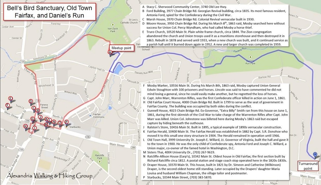
The starting point for Saturday’s hike was the Stacy C. Sherwood Center, a nice community center just north of Old Town Fairfax along Old Lee Highway. The route  consisted of two legs: first, a 1.7 mile loop (traced in red on the map below) along sidewalks through Old Town, taking in a few of the historic buildings along the way; and second, a 3.5 mile out-and-back hike through Daniel’s Run Park. The loop through Old Town was surely not as detailed as one of the 90-minute guided tours offered by Historic Fairfax City, but on the other hand, there wasn’t a $5 per-person fee, either! Since our goal was to keep moving, rather than stopping at each site for a lengthy discussion, I handed out a little map with descriptions of the sites taken from the Historical Marker Database. (A pdf version is available here.) This also had the fringe benefit of helping me to keep my mouth shut. (What was that quote from Abraham Lincoln again? “It is better to remain silent and be thought a fool than to speak out and remove all doubt.”) 😀

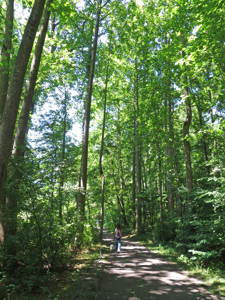
Bell-Daniels HikeStriking out east along the Daniel’s Run Trail (traced in blue on the map above), we passed a pleasant little pond with a fountain and a blue heron keeping an eye on things before we disappeared into the deep woods. The cool quiet and tall trees are so peaceful that, except for the occasional signpost indicating a path leading to one of the surrounding streets, you would almost think you left the city behind!

Sunday’s hike was a lot more “countrified” — after leaving Colvin Run Mill and entering the Difficult Run Trail, it was 5.5 miles of shaded dirt and mud trails, moderate to easy difficulty level, and broken only by one road and four stream shady crossings. I hadn’t been there in two years, but nothing has changed, and the stream crossings are sturdy enough that Difficult Run has to be really high in order to prevent a crossing.

All told, the two hikes yielded 10.7 miles of smiles. I really like coming up with fresh routes to hike rather than the same old cookie-cutter hikes that everyone knows by name. That’s not to say the familiar ones are bad; it’s just like retelling a favorite story — you already know how it ends. The only rub is finding the time to reconnoiter them in advance, since the map and the real thing can be considerably different!

Posted in Hiking, Photography | Tagged , , , , , , , , , , , | 3 Comments

Exercise is excercise isn’t it?!

Joanne's avatarMum... how much longer?

It all comes down to motivation doesn’t it and what works for you! 🙂

Walks in the forest - great exercise!

View original post

Posted in Hiking | Tagged | Comments Off on Exercise is excercise isn’t it?!

Dawn at Cub Run and a rattling good time

This past weekend we did something old and something new*; a Sunday hike at Bull Run Mountain, which we’ve visited many times before, and a Saturday hike along Cub Run, near Chantilly VA.

Cub Run is a tributary of Bull Run, and starts from just south of Dulles Airport and meanders south about 10 miles to where it flows into Bull Run southwest of Centreville, VA. There’s quite a network of trails along Cub Run, but I had not hiked any of them, so for the first outing I chose to take advantage of the Cub Run RECenter as a jumping-off point for a roughly 5-mile hike north and south of the center. A map recon was good enough to announce the hike, but since I hadn’t visited before, I hiked the route by myself at dawn a couple of days before the group event. What a rewarding visit! Click on the photo below to view a Flickr slideshow in a new window.

Dawn at Cub RunDawn is always when all the animals are out and on their best behavior, so to speak, and if you’re by yourself, it’s much easier to go unnoticed. Quite a few deer were out, including a cautious doe and her unconcerned fawn, and a heron flew over just as I was finishing up, with its characteristic crooked-neck flight posture. (Surely that’s uncomfortable!) The actual hike on Saturday was pleasant, but since it was much later at 10 am and with lots of folks, it was a much different experience.

Sunday’s hike at Bull Run Mountain was pretty straightforward, and a 74-degree overcast day made for a pleasant hike. An alert hiker notified me the day before that the Bull Run Mountain Conservancy recently changed its usage guidelines to ban dogs. No reason was given, but from what I’ve seen recently, I imagine there were just too many complaints involving hikers allowing dogs to run off their leash. (During our recent hike to Fort Stevens, one of our hikers was knocked down by large dogs running unleashed. Fortunately she wasn’t hurt, but the incident could have gotten out of hand and been much worse.)

Bull Run Mountain summit, looking westAnyway, Bull Run Mountain has one of the best payoff to sweat ratios around, since a relatively easy 2.5-mile climb yields a rewarding view west from the rocky cliffs, with the Appalachian Mountains in the distance. While enjoying the view, we glanced down and noticed someone else enjoying the midday sun on the cliffs: a big timber rattlesnake! It was obviously aware of our presence but unconcerned, since it was still sunning itself when we left.

Timber rattlesnakeIn addition to the changed usage guidelines at the conservancy, there’s another notable charge in the area: the Haymarket Village Center has been completed at the nearby intersection of I-66 and US-15. Purists might lament any construction whatsoever in the area, but I suppose the residents of Haymarket are just as entitled to groceries as everyone else, and it doesn’t really take up that much space. A fringe benefit is that there are now a few nearby places you can make a pit stop before and after hiking, if you aren’t overly fond of portable toilets, as well as a few more restaurants for lunch.

* No, no; not any of this kind of old and new stuff. Hiking, not getting hitched.

Posted in Hiking, Photography | Tagged , , , , , , , , , | 1 Comment

Sesquicentennial and a sultry garden

Last weekend I went on a couple of hikes that were about as far apart in both subject matter and venue as you can get! On Saturday we went on a 6-mile hike in Washington D.C., on the sesquicentennial anniversary of the Confederate attack on Fort Stevens, and on Sunday we made an early morning visit to Kenilworth Aquatic Gardens, also in Washington D.C., to check out the flowering aquatic plants.

Hike MapOn July 12th, 1864, a Confederate force commanded by General Jubal Early attacked Fort Stevens, on the north boundary of Washington, after marching around the Union Army of the Potomac through the  Shenandoah Valley, crossing the Potomac River and through Frederick, Maryland, and defeating a force commanded by Union General Lew Wallace during the Battle of Monocacy on July 9th. It was the only time Washington was attacked during the Civil War. Because President Lincoln observed the battle from the parapets of Fort Stevens, it was also the only time a sitting U.S. president came under enemy fire.

Our hike followed a route somewhat like Early’s march in miniature: we started from Brightwood Recreation Area, we hiked west and north through Rock Creek Park (our own “Shenandoah Valley,” so to speak) and popped out of the woods a mile north of Fort Stevens on Holly Street Northwest. From there we roughly followed Early’s route of advance south towards Fort Stevens, along Georgia Avenue NW. Just north of the fort we stopped at Battleground National Cemetery Park, where a ranger came out and greeted us, handed out sesquicentennial booklets, and gave us a short pitch about the cemetery. It was as though we’d arranged for it in advance!

We continued south to Fort Stevens, where there was a crowd, flags, tents, reenactors dressed in period clothing and — just as we got into position to watch — a Union artillery section fired their 6-pounder brass Napoleon cannon in a salute! After that we continued the final mile back to Brightwood Recreation Area to end the hike. For some reason everything in the hike went off perfectly, even the unplanned bonuses! That certainly doesn’t happen very often…

The next day started very early, 8:00 am at Kenilworth Aquatic Gardens. Every mid-July is when the lotus, water lily, and orchids bloom at the gardens, so it’s an event I don’t like to miss. The gardens are boxed in by marshy ponds and the Anacostia River, so there’s just not enough room for much of a hike. However, the River Trail is screened from the hubub of the visitors in the gardens, so if you’re quiet you can spot any number of critters. 🙂

It’s not often that everything works out even better than planned, but one thing’s for sure: when it happens, make sure to take credit for it!

Oh yes, what was the “sultry” part? Well, both the temperature and humidity were in the high 80s at Kenilworth Aquatic Gardens, so it was like an outdoor Turkish bath!

Posted in Hiking, History, Photography | Tagged , , , , , , , , , , , , | Comments Off on Sesquicentennial and a sultry garden

Whole cloth

Last weekend turned out to be a busy weekend for hiking. Early in the week I planned a hike in Reston on Saturday, but left Sunday open because the weather forecast predicted a good chance of thunderstorms. It wasn’t until Saturday that the forecast was revised to a sunny day, leading me to come up with a couple of hikes for Sunday out of whole cloth.

IMG_7904aSaturday morning we went for a 5.5-mile hike around Lakes Audubon and Thoreau in Reston. There are hiking paths throughout Reston, all paved with asphalt, and fairly flat with a few hills here and there. Given the fact that Reston is a planned community with restrictive bylaws, it’s ironic that Lake Thoreau is named for Henry David Thoreau, the American author and philosopher noted as a development critic and tax evader, best known for his book Walden, about living a simple life in a natural setting, and his essay “Civil Disobedience,” in which he argued that government is more harmful than helpful, and citizens should not blindly acquiesce to government authority or pay taxes if they are perceived to be the source of injustice. In any case, it was a pleasant if fast-paced hike (over 3 miles per hour), followed by lunch at Cafesano, a cafeteria-style Italian/Mediterranean restaurant overlooking Lake Thoreau from a shopping mall east of the lake. A Google map of our hiking route is here.

By Saturday the forecast for Sunday was revised to sunny and a high temperature in the mid-70s, from the 50/50 chance of thunderstorms that was previously predicted. A beautiful day demands a hike to match, so I reached in my back pocket and scheduled a Sunday morning hike at Scott’s Run, along the south bank of the Potomac where I-495 crosses over the river to the west of Washington D.C. Scott’s Run Nature Preserve is only 384 acres, which rules out a long hike, but the waterfall and river cliff overlook, along the Potomac on the west and east sides of the preserve, respectively, made for a nice hike of almost 2.5 miles.

Belle Haven Country Club, located along the Potomac just south of Old Town Alexandria, puts on a great Independence Day fireworks display every year, and even if you aren’t a club member, you can enjoy a great view of the fireworks from along the Mount Vernon Trail, just north of the Belle Haven Park along the Potomac. The fireworks display was originally scheduled to take place on the evening of Thursday, July 3rd, but due to the thunderstorms it was postponed until Sunday evening. So it was only natural for us to hike south along the Mount Vernon Trail from Jones Point Park to Dyke Marsh, and conveniently stopping on our way back just as the fireworks display began at 9:30 pm. In addition to the fireworks, starting the hike at 8:00 pm meant we were hiking during Golden Hour, which provided some opportunities for nice photos. (Not that I took very good advantage of them.) The evening hike was 5 miles round trip, so those who did both Sunday hikes managed a respectable 7 miles of hiking, and all three together added up to almost 13 miles.

This coming weekend is looking like it will be the complete opposite of last weekend. Both Saturday’s and Sunday’s hikes were planned in advance, being tied to a sesquicentennial anniversary and the probable peak bloom time frame for aquatic flowers, respectively. In addition, this morning I added an moonlight hike in Old Town Alexandria, hopefully to catch the City of Alexandria’s birthday fireworks display. This time around, though, the weather forecast has been sunny and mild for both days, but now a chance of thunderstorms is creeping back into the picture for Sunday.

Posted in Hiking, Photography | Tagged , , , , , , , , , , , , | Comments Off on Whole cloth